Article

GIS-Based Assessment of the Chestnut Expansion Potential: A Case-Study on the Marvão Productive Area, Portugal

by
Abel Rodrigues
1,2,*,
Alexandre B. Gonçalves
3,
Rita Lourenço Costa
2,4 and
Alberto Azevedo Gomes
2
1
IDMEC, Instituto Superior Técnico, Universidade de Lisboa, Av. Rovisco Pais, 1049-001 Lisboa, Portugal
2
INIAV—Instituto Nacional de Investigação Agrícola e Veterinária, 2780-157 Oeiras, Portugal
3
CERIS, Instituto Superior Técnico, Universidade de Lisboa, Av. Rovisco Pais, 1049-001 Lisboa, Portugal
4
Centro de Estudos Florestais, Instituto Superior de Agronomia, Universidade de Lisboa, 1349-017 Lisboa, Portugal
*
Author to whom correspondence should be addressed.
Agriculture 2021, 11(12), 1260; https://doi.org/10.3390/agriculture11121260
Submission received: 30 October 2021 / Revised: 6 December 2021 / Accepted: 9 December 2021 / Published: 13 December 2021

Abstract

:
Sweet chestnut is a relevant species in Europe for the production of timber and fruit, alongside environmental effects such as biodiversity of protection against soil erosion. In Portugal, chestnut is cultivated mainly for fruit production, in two areas, in the North and the South of the country, with moderate water deficit and low slope and at altitudes higher than 500 m. The current area (845 ha) of the southern so-called Marvão Protected Designation of Origin, of a fortyfold lower order of magnitude by comparison with the Northern productive area, has a significant expansion potential, given its similarity with contiguous areas in the same region. In this context, the main objective of the present work was the evaluation through geographic information analysis of that expansive potential, by comparison of physiographic profiling of the current production area with contiguous areas. A GIS-based characterization of current and potential chestnut areas in Marvão is presented. The methodology involved (i) digital profiling of the main classes/values of the geographical spatial ecological fingerprint considering topography, soil and microclimate variables in the areas currently occupied with sweet chestnut stands and (ii) the evaluation of the distribution of that environmental fingerprint in the whole Marvão productive area, for extending the cultivation to contiguous areas with a similar ecological fingerprint. An enlarged 9889 ha chestnut area was proposed, allocated for high forest stands aiming at agroforestry fruit production and coppiced stands for timber production and environmental protection, corresponding to 4590 ha and 5299 ha, respectively. Fruit production was proposed to field slopes of 0–4% and 4–8%, and altitudes between 400 m and 500 m. Presumable high-quality sites allocated to temporary dry/irrigated cultivations were also proposed for fruit production, in the same slope classes and altitudes higher than 500 m. Timber production and environmental protection were proposed for slopes within 8−12% and >12% ranges. This selection took into account the logistical feasibility facilitated in lower slopes for intensive mechanized management operations. This methodology permits a future field evaluation of site indexes, productivity, and correlations between environmental variables and stand biometry.

1. Introduction

The most relevant chestnut species in Europe amongst the thirteen species from the Castanea genus is Castanea sativa, M., commonly called sweet chestnut, a typical multipurpose species. Sweet chestnut stands have been extensively managed in high forest and coppice agroforestry land covers aiming production of edible fruits and timber, under a context of encouraging expansion and regeneration of the species in Europe [1,2,3].
Experimental evidence points to the convenience of coppicing management in shortening the growing lifecycle. This topic shows potentially positive effects, e.g., in timber production and environmental agro-forestry, being implemented primarily in higher altitudes, aiming for soil and landscape conservation and biodiversity. The contribution of chestnut stand management for carbon sequestration and mitigation of climate change was also considered [4]. The survival rates of individuals of these species under Mediterranean conditions is problematic depending on factors such as fire disturbance, shade from competitive late-successional species, grazing pressure from goats or repeated gall wasp (Dryocosmus kuriphilus) attacks [5]. A decline of the financially feasible cultivation of sweet chestnut in Europe occurred in the 20th century, due to the introduction and spread of severe diseases such as the soil-borne ink disease (Phytophthora spp.) and the chestnut blight (Cryphonectria parasitica) [6,7]. Nowadays woodlands of the species correspond to about 2.5 million ha in Europe, mostly in the Mediterranean and Sub-Mediterranean areas corresponding to a climatic envelope with mean annual temperatures ranging between 8 °C and 15 °C and minimum annual precipitation between 600 mm and 800 mm [8,9]. For Central and Southern Europe, under the current context of climate change, chestnut is considered a potentially resilient tree species (e.g., [10,11]). Castanea sativa woodlands have traditionally been managed under different agroforestry systems (AFS) [8,12,13,14]. Several types of AFS include chestnut trees as the main element but differ concerning their productive aim. The main agroecosystems services provided by chestnut AFS in European Mediterranean and Atlantic regions are food provision from fruit, biomaterials (wood and biomass), bioenergy, climate regulation and control of soil and vegetation erosion (e.g., [14]).
In Portugal, chestnut is cultivated mainly for fruit production in orchards under low summer rainfall, moderate water deficit and low slope, mainly in Northern and Central mountainous Portugal. This contrasts with Central and Western Europe where, by far, the largest proportions of chestnut areas are coppices. The stands aiming for fruit production are widely distributed in the Northeastern part of the country, covering 35,000 ha, along with a smaller area of about 850 ha corresponding to the designated Marvão Protected Designation of Origin. This designation was established by the Portuguese and European authorities and includes the county of Marvão and the São Mamede mountain range, located in the Central Eastern part of the country.
The fruit productivity of chestnut stands is around 1300 kg ha−1 y−1, with a recent decreasing tendency due to fungal ink, cancer diseases or soilborne Phytophthora cinnamomi pathogen [15]. Under adequate sanitary conditions, chestnuts maintain steady increasing fruit productivity from about 20-year-old to 60-year-old or even older trees, within stand densities up to 400 trees per hectare. The usual production ranges between 10 kg and 90 kg per tree, and as high as 250 kg to 300 kg per tree for high productive trees [16]. Should the sanitary status or stand management be improved, and the fruit production perspectives would be for increasing to about 1800 kg ha−1 y−1 in 2022 and about 3000 kg ha−1 y−1 in 2030 [17]. The cultivation of chestnuts for fruit production is a profitable activity and the expansion of their areas under adequate management would therefore be determinant to boost the social and economic development of the rural areas involved. Timber production is possible in steep and stony hilly areas where fruit production is not financially feasible, and in adult stands can range between 5 m3 ha−1 y−1 and 10 m3 ha−1 y−1. In Portugal, the current area and productivity per hectare are restrained by as much as 50% due to the impact of the diseases and pests already referred [2,14,15,16].
The wide range of factors influencing chestnut stand management is related to variables associated e.g., with climate, topography, soil, or even natural vegetation. Those factors are not directly controllable by anthropogenic actions, and thereby agro-forest management should be conducted for optimizing their impact and to maximize the long-term sustainability of chestnut stands. In Europe, transformations have been proposed, with conservation and landscape protection objectives [18], such as the conversion of coppicing to high forest systems for reducing fire risk, or conversion of high forest to coppice on steep slopes to improve the hydrological balance and soil protection [19]. The relevance of environmental factors in the productive potential of chestnut stands and their impact on forest management is widely presented in the literature The better climate conditions for chestnut stands are those without significant frost risks, shade and cool environments, annual precipitation ranging between 600 mm and 1500 mm, annual sunlight periods ranging between 2400 h and 2600 h, mean annual temperatures between 9 °C and 13 °C and long-term maximal mean of annual maximum temperatures of about 27 °C. Climate variables related to air temperature, precipitation and evapotranspiration were found as the most contributive to the variance in chestnut stand biometry, with, e.g., sprout and stool density of 0.43 and 0.59 [20].
Chestnuts are adaptable to various climates such as the warm and rainy Atlantic maritime, the hot and dry Mediterranean, or the severe continental with rigorous winter and hot summer. This plasticity of the species is determinant to the aforementioned resilience to climate change in Europe. In this context, climate factors contribute to the regulation of physiological processes such as budbreak emerging, summer evapotranspiration, soil moisture storage or drought season length. On the other hand, trees can control stomatal opening for regulating photosynthetic gas exchanges and transpiration. This latter effect can be enhanced in Mediterranean-like climates, by implementing cultivations at higher altitudes linked to lower environmental temperature and higher moisture, which is also contributive to minimizing hydric stress [21]. Overall, although adult chestnut stands withhold severe drought conditions, young trees are considered as far more sensitive to water stress. Thus, coppicing by allowing to obtain higher soil water and nutrient amounts, can enhance plant growing when water scarcity is not very drastic [21,22]. Chestnut prefers sedimentary or siliceous soils with acidic to neutral conditions, tending to occupy hills and ridges because their roots tend to decay in poorly drained soils. Soil drainage is a necessary condition since chestnut is sensitive to water-logging and rocky materials can exist up to about 30%, provided that the soil is sufficiently deep to provide the necessary fertility and supply water needs in dry summer [13,16,23,24,25]. The adequate soil texture should be sandy loamy, loamy sand or silt loamy, typical of undifferentiated soil types, e.g., cambisols, and not too heavy wherein productive potential can be very low. A finer texture can be tolerated if the soil exhibits an adequate structure.
The availability of soil organic matter, at amounts higher than 2%, besides improving soil structure, porosity and water and nutrient availability and reducing waterlogging, is a factor potentially allowing to minimize the impact of chestnut ink disease [26]. Elevation between 700 m and 1000 m is mentioned as adequate for chestnut fruit production [13]. The intensity of agroforestry management is dependent on the site quality and productivity, insofar that higher site index (SI) values allow for more intensive clear-cutting or reduction of rotation times [1,27,28]. A study about chestnut for timber production in Northern Spain showed that climate and edaphic variables were those better explaining SI [29]. Altitude was shown as closely correlated to more than 85% of the climatic variables, such as precipitation, mean annual temperature or potential evapotranspiration, and thereby influencing SI. Slope was not shown as particularly relevant, with timber productivity of coppice stands in steep slopes being positively affected by increased rainfall, and negatively influenced by extreme seasonal air temperature variations. The lack of waterlogging is also a determinant for the mitigation of ink disease [29].
For chestnut aiming timber production in Northern Spain, models including edaphic and climatic variables explained the higher percentage of variability of 52%, while genetic factors explained the remnant [30]. Sand content was shown as the main soil-related variable which controls height growth of the chestnut coppice stands with soils, with sand amounts higher than 57% delivering significant SI gains. SI was also higher in sites with soils with clay amounts lower than 29% and with summer precipitation exceeding 151 mm, confirming the low adaptation of chestnuts to clay soils due to compressibility and low aeration.
Geographic information systems (GIS) allow evaluating the impacts of isolated ecological factors, related to climate, physiography, and soil, in site quality and temporal and spatial variability of forest productivity (e.g., [31,32,33,34]). The analysis of the impact of isolated ecological factors permits the identification of spatial-temporal interconnectedness between these factors and forest management traits. GIS methodologies can be relevant for the modelling and prediction of new areas for implementation of chestnut for fruit, timber production, ecological protection, or agro-forest restoration [20,34,35]. Also, such an approach of environmental impact analysis would allow evaluating how such factors constrained previous landscape uses, contributing to the optimization of the current management decision processes [20].
In Portugal, a GIS-based study, using an 8 km × 8 km cell grid map, showed that 86% of the cells with prevalence of chestnut stands corresponded to altitudes ranging between 500 m and 1000 m [34]. GIS was used to establish relationships between forest variables and chestnut trees in these AFS, showing that ecological variables can condition stand management, being, therefore, a key issue for planning the expansion of areas of chestnut cultivation [36]. Slope and altitude were shown as significantly correlated with stool and sprout density. The soils in the study were considered adequate for chestnut cultivation and derived from similar lithological substrates of quartzites, sandstones, schists, granites and slates and thus overall biometric data was not found to vary with the available soil datasets.
In all the above context, the present study aimed to estimate the potential total area for expansion of chestnut stands in Marvão productive zone, for fruit and timber production and environmental conservation. A spatial approach was followed for evaluating the prevailing soil, altitude, slope, and climate profiles in the current chestnut areas. This approach was followed under the assumption of similarity of sites adjacent to the current productive area in the whole zone. These physiographic profiles were overlaid with the area distribution of land use classes considered as major sources for the generalization of the potential locations for installing new chestnut stands: permanent pastures, pastures with permanent cultivations, herbaceous vegetation, shrubs, and temporary dry/irrigated cultivations. This study was encouraged by authorities to boost the local economy and preserve the unique and valuable genetic resources of this region endangered by rural depopulation. This strategy should also present global relevance for the evaluation of crop production. The obtained potential area should thereby reflect the physiographical and landscape aptitude of this region for the development of chestnut productive clusters for fruit and timber.

2. Materials and Methods

GIS was used to evaluate the possible extension of the current area, of around 845 ha, of sweet chestnut for fruit production in the Marvão productive region. The area specifically under study includes Serra de São Mamede, a small mountain range that separates the basins of the Tagus (north) and Guadiana (south) rivers. This productive area is one of the four so-called Protected Designation of Origin regions in the country for chestnut cultivation. An extension of the surface cultivated with sweet chestnut was considered as possible, due to the apparent environmental similarity of the whole studied area regardless of the current occupation with stands of this species. Empirical historical evidence points furthermore to an old-time tradition relevance of sweet chestnut fruit production in the economic and social fabric of the region.
The methodological strategy was, therefore: (i) to characterize the prevailing classes or values of the geographical spatial ecological fingerprint considering variables linked to topography, soil and microclimate in the current chestnut area; and (ii) to evaluate the distribution of that environmental fingerprint in the entire Marvão productive area, for generalizing the possible cultivation with sweet chestnut to additional areas not occupied with the species, but exhibiting topography, soil and climate profiles similar to the current chestnut areas. The Marvão productive area has a maximum elevation of 1025 m, covering an area of approx. 30 km by 10 km along the NE-SW direction, and is included in the namesake natural park, a protected area located within the limits of the range (Figure 1). The range influences a microclimate with rainfall and humidity levels that are higher than the surrounding territory. Despite its small area, local climatic diversity and soil typology support a combination of Atlantic forest with Mediterranean land cover. A reference land-use dataset was used for determining and characterizing the current sweet chestnut area.
The footprint of slope and altitude of the current sweet chestnut area, resulting from the overlay of the land use and elevation datasets, determined the choice of two altitude classes, “400–500 m” and “>500 m”, and four slope intervals, “0–4%”, “4–8%”, “8–12%” and “>12%”, as physiographical criteria for the estimation and evaluation of the potential expansion area of chestnut stands for fruit and timber production. The land use map was also considered for obtaining areas of five land-use classes, corresponding to land occupations with low economic value, which can be considered as a first filtering criterion for extending the current sweet chestnut area. These classes were “permanent pastures”, “pastures with permanent cultivations”, “natural herbaceous vegetation”, “shrubs” and “temporary dry/irrigated cultivations”.
Another constraint for spatial modelling was the soil map of the region. The boundary of both the current and potential sweet chestnut areas encompassed by this study was defined by the extension of four layers of this soil map, defining a study area of approximately 25 km in length (N-S) and 20 km in width (W-E), covering the productive zone with a slightly irregular shape due to the Spanish-Portuguese border east of the range. The resulting datasets were the output of a further digital overlaying of the soil and land use datasets with altitude and slope datasets, considering the physiographical and soil classes obtained from the digital datasets relative to the current chestnut area.
The methodology to obtain the potential chestnut area used a GIS in three sequential stages (Figure 2). Firstly, the land use map was used to select the current chestnut area. In the second stage, the current chestnut area dataset was then combined with other datasets (elevation, slope, soil, and climate) to characterize the current chestnut stand distribution, with the extraction of environmental ranges for elevation, slope, and soil types confirmed as typical for chestnut habitat preferences from literature. In the third stage, the potential chestnut area was obtained from overlaying the environmental ranges of the current chestnut area with the five soil use classes, which were considered as sources for the generalization method to obtain the areas for chestnut installation.
For delivering the described modelling the following digital spatial datasets used are briefly described as follows:
Land use/cover cartography: The reference thematic map for land use/land cover data is the land occupation map (COS), published by the Portuguese governmental agency of territory and spatial planning (Direção-Geral do Território). The dataset, in vector format (polygons, non-overlapping), has a minimum cartographic unit of 1 ha, mapping the landscape units according to a 5-level hierarchical classification that is detailed enough to indicate the dominant species in agriculture or forest classes. The 2015 edition (COS2015 v1.0) at its most detailed level (level 5) was used to obtain the magnitude areas of current chestnut occupation and the abovementioned five land use classes considered for its expansion (Figure 3).
Soil classification: The soil dataset used was the soil classification map (1/50,000 scale compatible detail) edited by the Portuguese agency of agriculture (Figure 4).
Elevation: The elevation dataset used was the European Digital Elevation Model (EU-DEM 1.1, provided by the EU GMES/Copernicus package in Geotiff 32-bit format). It has a spatial resolution of 25 m with a vertical accuracy of +/− 7 m RMSE. In the studied area, elevations range between 230 m and 1018 m (Figure 5).
Climate: Climate data was extracted for Portugal from the most detailed Worldclim 2 Global Climate datasets [37]. This extensive collection of raster datasets (ca. 1 km2 cells) has average monthly climate data for minimum, mean, and maximum temperatures and precipitation for the years 1970–2000, obtained by the interpolation of monthly climate data of global land areas.
The climate variables, namely air temperature and rainfall, were deemed as not varying within the relatively small area of the study, after a short digital analysis with Worldclim 2 Global Climate datasets. Along the period 1970–2000, the long-term averages of the main climatic variables in the productive zone ranged between 13.1 °C and 14.4 °C for annual air temperatures, between 6.6 °C and 7.3 °C, and 22.4 °C to 23 °C for winter (December–February) and summer (June–August) temperatures, between 707 mm and 1153 mm for annual precipitation, and between 191 mm and 238 mm (winter) and 18 mm to 19 mm (summer) accumulated precipitations. Summer precipitation is significantly lower than 151 mm, a threshold [30] that determines its relevance in defining SI. The average annual and summer air temperatures were typical of a Mediterranean climate with this weather profile being surely enhanced in a context of climate change, which could lead to significant air temperature increases and precipitation decreases [38].
ArcGIS Desktop 10.7 (Esri, Redlands, CA, USA) was used to handle all described data and perform the spatial analysis operations. The cartographic basis was the elevation dataset with 25 m of spatial resolution, and all the other datasets were converted to raster or resampled to match the extent and resolution of this dataset.

3. Results

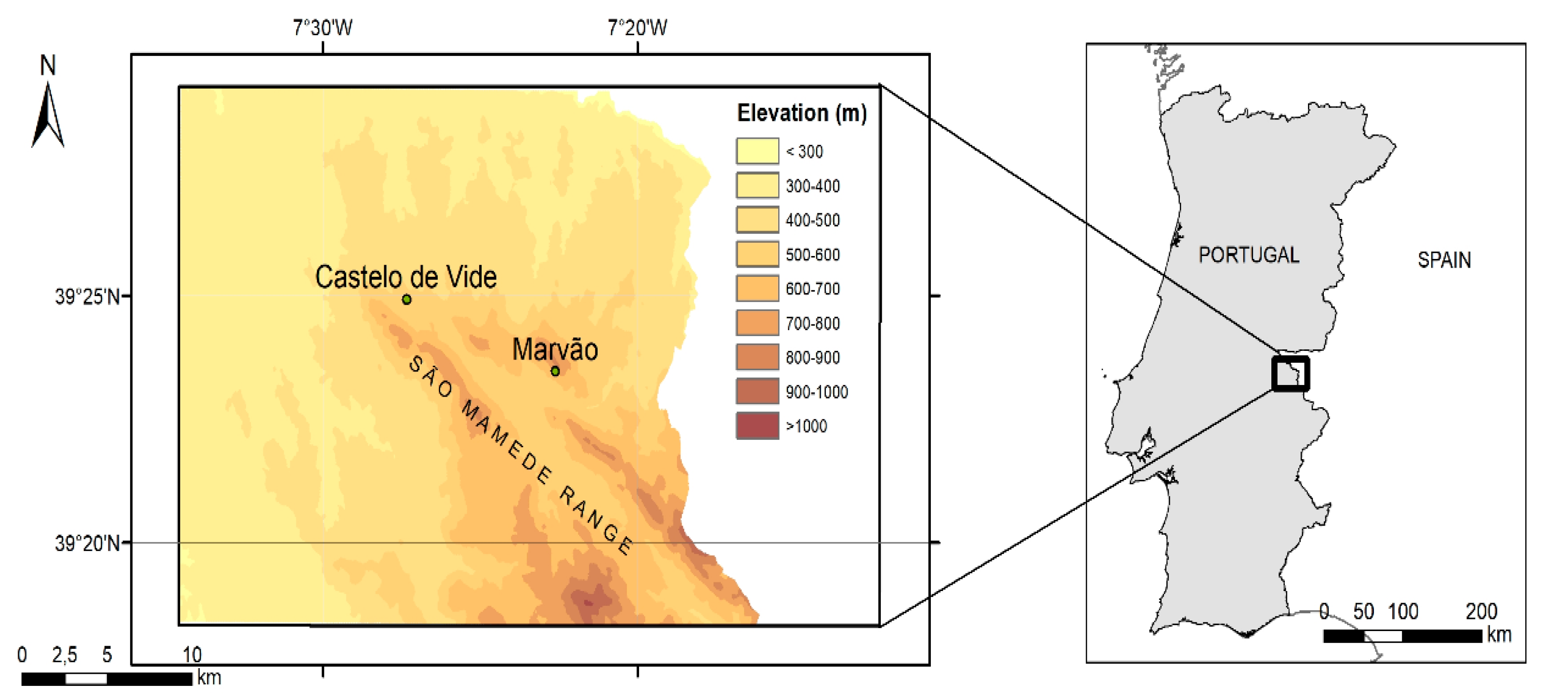
3.1. Slope and Altitude

Sweet chestnut covers 845 ha in the study area. Its distribution by slope interval and altitude classes is shown in Table 1.
A dominance of about 90%, or 760 ha, of the current chestnut area in the class of altitude higher than 500 m was observed (Table 1). This dominance is in line with a previous assessment [34], concluding that about 85% of the Portuguese chestnut tree area for fruit in 2006 lies above 500 m. The prevailing slope interval was >12% with an area of 558 ha, 66% of the total, followed by the 4–8% and 8–12% intervals corresponding to around 13.5% each and by the 0–4% interval with about 60 ha, 7.1% of the total chestnut area. The areas within 400–500 m altitude class and the 0–4% and 4–8% slope intervals, supposedly suitable for highly intensive managed chestnut stand for fruit production, corresponded to ca. 26.5 ha (3.0%) each. The high representativeness of slopes higher than 12% in the current chestnut area, of around 66% of the total (Table 1), is indicative of a marginal relevance of aspect for cultivation, considering solar radiation as essentially abundant for tree growth and development. Within the study area, the total available expansion was estimated as of around 27,930 ha (Table 2). The 4–8% and >12% slope intervals prevailed, with respectively 26.9% and 39.5% of the total area. From the slope class >12% sub-total, about 32.6% of the total area (9097 ha) was relative to altitudes above 500 m. The slope interval of 4–8% corresponds to an area of 7525 ha. The two altitude classes correspond to similar perceived areas with about 48.2% (13,460 ha) and 51.8% (14,470 ha) to the 400–500 m and >500 m classes, respectively (Table 2). The areas corresponding to the 400–500 m altitude class and slopes of 0–4% and 4–8% were about 3476 ha and 5402 ha, totalling 8878 ha, corresponding to 12.4% and 40.1% of the total area of 27,930 ha.

3.2. Land Use and Potential Expansion of the Chestnut Area

The total potential area for expansion of the chestnut stands was about 10,012 ha, from the soil and land use maps, corresponding to the five abovementioned land use classes and considering either the two altitude classes or four slope intervals (Table 3, Figure 6 and Figure 7) mentioned as the physiographic framework of the current chestnut area.
Using the four soil map layers in the Marvão region, the total available area of those five land uses was about 18,690 ha, regardless of slope and altitude. The potential total area of the five land uses considered in the altitude class ranging between 400 m and 500 m of 5690 ha was higher than that in the >500 m class, of 4322.6 ha, corresponding to about 57% and 43% of the total area, respectively. The total joint potential area of these land uses within the 0–4% and 4–8% slope ranges was about 5372 ha. The corresponding total potential area for the higher slope intervals was about 4639 ha (Table 3). Shrub areas were the larger contributor with about 59% or 5900 ha, followed by temporary dry/irrigated cultivations and permanent pastures with about 17%, or 1668 ha, and 16% or 1606 ha, of the total area, respectively (Table 3).
Shrub areas were located among all slope and altitude classes with percentages ranging between 1.3% and 17.7% of the total area, respectively for the slope intervals 0–4% and >12% and altitudes higher than 500 m. For the altitude classes 400–500 m and >500 m, the total percentages of shrub areas were 33.4% or 3344 ha and 25.5% or 2556 ha, respectively (Table 3). Temporary dry/irrigated cultivation areas corresponded to about 6.8%, or 677 ha, and about 9.9%, or 990 ha, of the total potential area of 10,012 ha, for the 400–500 m and >500 m altitude classes, respectively (Table 3). As expected, the slope intervals with higher areas were corresponding to lower values, with about 5.3% (533 ha) for 0–4% and 6.2% (617 ha) for 4–8% slope intervals, respectively (Table 3). The per cent areas of permanent pastures for 400–500 m and >500 m elevations were 12.9% (1296 ha) and 3.0% (310 ha) of the total potential area, respectively. The distribution of these later canopies within the altitude class 400–500 m along the four slope classes ranged between 1.2% and 5.2% of the total potential area, for the slopes >12% and 4–8%. An area of 1561 ha from permanent pastures, shrubs and temporary dry/irrigated cultivations was available at slopes in the 0–4% interval and altitudes between 400 m and 500 m. For the same altitudes, the area corresponding to these three land uses in the slopes ranging between 4% and 8% was about 2190 ha (Table 3). Especially relevant is the 597 ha area corresponding to the combination of slope classes of 0–4% and 4–8%, within altitudes higher than 500 m, given their potential for fruit production.

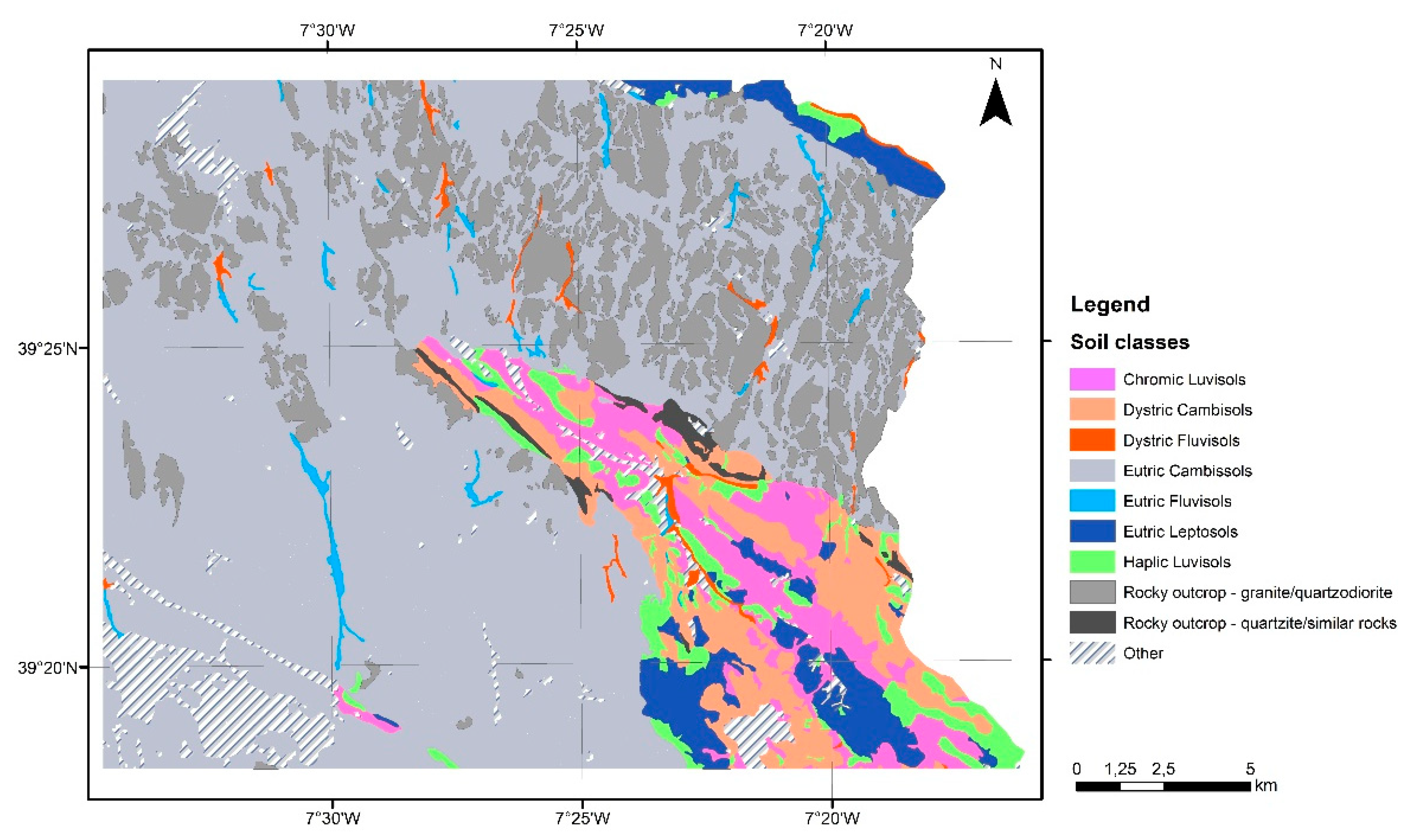
3.3. Soil Classes in Current and Potential Chestnut Areas

Table 4 shows the main nine soil classes of the existing 845 ha area of sweet chestnut. The dystric cambisols covering 309 ha (33.6%) and chromic luvisols and eutric cambisols over 194 ha (23%) and 156 ha (18.4%) dominate the soil type on higher than 500 m. Chromic luvisols, eutric cambisols, haplic luvisols, eutric leptosols and dystric leptosols were mainly located in altitudes higher than 500 m typical of the current chestnut distribution. Dystric cambisols, despite a predominance above 500 m, followed a more even distribution with about 30% and 6.5% of the total current chestnut area, within the two altitude classes (Table 4). Rocky outcrops showed also a more homogeneous distribution within the altitude classes with 3.5% and 7.2% of the total, respectively located in the 400–500 m and >500 m classes. Among the most representative surfaces, the rocky outcrops class was the most heterogeneous, insofar that a somewhat significant proportion of 6.9% of the current total sweet chestnut area with those surfaces in slopes higher than 12% contrasted with much smaller areas of about 0.1% and 1.5% in the other intervals. Fluvisols with a very small representation of about 4.4 ha in the current chestnut area are young soils whose formation was conditioned by the topography of the terrain in the same way as leptosols which scattered through an area of about 20% of the total. These are young aerated or waterlogged soils with incipient horizon differentiation having mostly AC-profiles.
Essentially, cambisols are an incipient soil group, wherein limited age with slight profile differentiation prevails in the definition of physical-chemical characteristics. Luvisols are usually well-structured and fertile, and in upland areas are commonly associated with cambisols.
Rocky outcrops of granites or quartz diorites with an area totalizing about 91 ha, or 11% of the total area from which about 7.3% and 3.5% corresponded to altitudes classes >500 m and 400–500 m, respectively. Rocky outcrops were significant surface areas covering existing sweet chestnut stands, overlaying, as aforementioned, soil layers with enough fertility and water retention.
Haplic luvisols on 70.7 ha (8.3%) and eutric leptosols and dystric leptosols, each with over 9.5 ha (1.1%), were the least represented in the current sweet chestnut area. In the current chestnut occupation, the relatively scarce areas of eutric and dystric leptosols occupy about 9.5 ha each. In the estimated potential areas eutric leptosols occupy about 85 ha and 338 ha concerning slope intervals 8–12% and >12% (Table 5).
The percentages of the physiographic area of the two altitude classes and four slope intervals with interest for chestnut cultivation (Table 2) show a distribution pattern that is closer to that of the potential chestnut area (Table 5) than to that of the current area (Table 1), insofar that this latter is, as above mentioned, characterized by the prominence of higher altitudes and slopes. Table 5 shows the potential chestnut area of around 9889 ha, resulting from layering the total 10,012 ha in Table 3, of five soil/land use classes, with two altitude and four slope intervals and with the areas of the main 9 soil types obtained from the soil topology of the Marvão current productive area; it also displays a physiographic profile wherein the altitude range of 400–500 m with an area of about 57% (5646 ha) of the total potential area, prevailing over the >500 m class with an area of about 42% (4243 ha). The lower slopes in potential areas show a higher weight than in current areas with the 0–4%, and 4–8% intervals being prevalent with 21% (2142 ha) and 32% (3157 ha) of the total potential area.
Areas of the altitude class 400–500 m show a prevalence of 0–4% and 4–8% slope intervals, respectively corresponding to about 3993 ha, corresponding to components of 1668 ha and 2325 ha or 17% and 23.5% of the total area, respectively (Table 5). These lower sloped areas can be better adequate for intensive management for fruit production due to the facilitation of mechanized logistics. Allocation to chestnut coppicing for timber production and protective agroforestry can be attributed to areas of about 1652 ha (17% of the total), corresponding to terrains with altitudes between 400 m and 500 m and slopes above 8%, and to 4243 ha (43% of the total) corresponding to altitudes higher than 500 m, could be allocated to timber and protective coppice forestry. The later area can be decreased to 3647 ha (37% of the total) by discounting 597 ha, relative to the soil use class of temporary dry/irrigated cultivations with a slope lower than 8% and altitude greater than 500 m, due to higher site fertility therein apt to the more profitable fruit production. The potential area of 3993 ha abovementioned for fruit production is thereby increased to 4590 ha. In the above context, the total areas attributed to fruit production and timber and protective agroforestry will be about 4590 ha and 5299 ha, respectively.
The soil distribution profile in the estimated sweet chestnut potential area (Table 5) was essentially the same as that corresponding to the current chestnut areas, thus being not strictly relevant for the allocation of potential chestnut productive areas. This reflects the relative homogeneity of the Marvão region, with the difference that dystric leptosols were nonexistent in the potential chestnut areas, and existent with about 9.5 ha in the current chestnut area (Table 4). Eutric and dystric cambisols with around 4660 ha and 846 ha and rocky outcrops with about 2426 ha prevailed in the potential productive area. Rocky outcrops represent about 2426 ha, with about 1100 ha corresponding to the two lowest slope intervals with about 1100 ha corresponding to the 0–4% and 4–8% slope classes and 400–500 m altitude range, Dystric cambisols, chromic luvisols, eutric leptosols, haplic luvisols and eutric fluvisols followed, with lower percentages of 8.5%, 6.1%, 5.8%, 5.3% and 1.9% of the total potential area for chestnut stand expansion. These five soil classes correspond to higher altitudes and/or slopes. Eutric leptosols, considered as very poor mineral soils, show a relatively substantial representation of 577 ha, potentially allocable to chestnut coppicing, corresponding to their prevalence at altitudes higher than 500 m. In absence of waterlogging problems, the estimated areas of eutric and dystric fluvisols in potential chestnut areas of about 193 ha and 45 ha, mainly in the 0–4% and 4–8% slope intervals, would be adequate for the extension of chestnut high forest area to fruit production.

4. Discussion

Physiographic and environmental strata profiling have been used in Spain [20,22] and Portugal [34] for digital mapping of the suitability of chestnut stands and the selection of stands to be studied. In this work, physiographic profiles of altitude and slope were the main distinctive characteristics of the current and potential expansion areas of chestnut stands, because of the aforementioned similitude of climate and soil type mosaic in the whole Marvão productive area. Correlations between physiography defined through altitude and slope are established with chestnut biometrical and stand variables such as stool density, basal area, or crown density. The influence of site altitude in chestnut growth appears thereby to be mainly indirect in relation with climatic variables [20], explaining about 40% to 47% of the overall variability from multivariate analysis in sets of climatic, stand biometry and understorey floristic composition. The correlations of joint physiographic variables with sprout and stool density and crown coverage were 0.44, 0.43 and 0.6, respectively. This physiographic criterion was considered, as abovementioned, with priority for fruit production, due to the more facilitated logistical feasibility of forest intensive mechanized management operations such as ploughing, understory liming, clearing or irrigation in higher slope and, to a lesser extent, higher altitude [13,23,25,39,40].
The estimated chestnut potential area of 9889 ha resulted in a significant enlargement from the current chestnut area for fruit production of around 845 ha, with about 4590 ha and 5299 ha attributed respectively to profitable fruit production and timber and protective agro-forestry. Chestnut timber was shown as a feedstock with a good aptitude for construction corresponding to individuals with diameters higher than 60 cm [13]. The management of stands aiming at timber protection has also impact on carbon sequestration and stocks in ecosystems, simultaneously with environmental conservation. In mediu–long periods, the planning of management in these stands should thereby diversify to take on account these environmental aims (e.g., [4,41,42]). The logistical upgrading is obviously determinant for the financial feasibility of high forest stand management for fruit production. In Spain, a conversion on high forest chestnut stands aiming for fruit production to coppice for timber in steep slopes was proposed for improving hydrological balance and soil protection. In Portugal, chestnut stands for fruit production are located on medium and low slopes, also increasingly appearing in lowland agricultural areas. These stands with heterogeneous tree dispositions can also appear in more mountainous areas within a fauna and flora biodiverse landscape [12,13,14,16,23].
The relevance given to sweet chestnut coppicing for timber/environmental protection to altitudes higher than 500 m is related to the higher sensitivity of younger trees to a higher temperature and lower atmospheric moisture prevalent in lower altitudes. The implementation of coppicing with young plants exhibiting full mature root systems, formed since the beginning of the production cycles, would allow for higher wood productivity (e.g., [21]). Also, from a study implemented in a set of 97 experimental conditions [22], it was concluded that optimal growing conditions for 1- to 16-year-old young chestnuts from seedling and clones, were altitudes below 800 m, with climatic conditions such as evapotranspiration lower than 650 mm or summer precipitation higher than 130 mm.
The Marvão productive region shows a typical Mediterranean climate, with a scarcity of accumulated precipitation in summer on only about 18 mm to 19 mm. Drought and environmental heating are associated with the inevitable context of climate change and can inclusively have implications in the sanitary status of chestnut stands. The necessary equilibrium between achieving air temperatures e.g., adequate for flowering and fruitification, while avoiding the drought and environmental heating can be fulfilled through the installation of chestnut cultivations at distinct altitudes [20]. This is because air temperature tends to decrease with altitude alongside possible increases in precipitation and moisture.
On the other way, on a micro-scale perspective, one advantage of the installation of stands in altitudes between 400 m and 500 m could derive from decreasing of chestnut growth with elevation, due to the negative influence of lower air temperatures, with repercussions in adequate flowering and fruitification [22]. In this context, positive and negative correlations were shown [29] between altitude and climatic air temperature and precipitation related variables with absolute values ranging between 0.85 and 0.93 for chestnut stands aiming at timber production in Spain. Furthermore, higher site slopes in conjugation with stoniness reduce the soil water holding capacity. Slope configuration influences also drainage through the concavity, convexity, or flatness of the terrain [13,20,23].
Temporary dry/irrigated cultivations were also be considered as favorable for presumable high-quality chestnut sites, given the intensive agricultural management inputs [14]. Indeed, an area of 597 ha of temporary dry/irrigated cultivations, with slope lower than 8% but altitude higher than 500 m, due to high site quality was directed for the more profitable fruit production. Regarding fruit production in a Mediterranean area, the inclusion of 597 ha of potential high-quality sites above 500 m, corresponding to temporary dry/irrigated cultivations, would enhance the mild effects of lower temperatures and higher precipitation [13,14,20,23].
Eutric and dystric cambisols prevalent in the current area were also mentioned in chestnut stands aimed for timber production in Spain [26]. These soils can generally make good intensive agricultural land. In steep slopes, cambisols are best kept under forestry, notably in highlands. Major areas of these soils should deliver adequate fertility conditions for high fruit productivity. A good indicator for the area expansion is the predominance of cambisols and luvisols in either current or potential areas, insofar that these are commonly associated soil types, slightly differentiated, with a good potential aptitude to chestnut implementation and management [26].
The allocation of these soils to future fruit and timber stands should be allocated under the defined general principles of slope and altitude intervals. Chromic and haplic luvisols can be considered as somewhat differentiated fertile soil classes, which should be allocated for timber/environmental high forestry and fruit production. Eutric leptosols are the poorest occurring in the potential expansion area, mainly located in altitudes higher than 500 m and slopes greater than 8%.
In the Marvão productive region, the installation of new chestnut areas has taken into account the problem of ink and blight diseases, by planting hybrid varieties used as rootstocks, selected from the breeding program on course, based on controlled crosses between sweet chestnut, the European chestnut, and the Japanese and Chinese chestnut species, very resistant to these diseases. A large-scale greenhouse unit was thereby created for rootstocks production, providing improved plant material for expansion of the area of sweet chestnut plantation for fruit production. The installation of new stand areas should be complementary with good plant material and adequate management. The impact of diseases is highlighted by bad management practices leading, e.g., to low amounts of soil organic matter, excessive pruning, or immoderate ploughing with heavy machinery disruptive of plant roots. An impoverishment of species’ natural ecological range and autecology and of soil fungal community thereby occurs with loss of biodiversity and stand vigour [9,12,13,43].

5. Conclusions

An exploratory GIS-based methodology allowed to estimate a substantial potential expansion of the current 845 ha productive area to 9889 ha, with about 4590 ha and 5299 ha attributed to profitable high fruit production and timber and protective agro-forestry coppice.
Under a relatively homogeneous soil mosaic, slope and altitude classes were found as the main profiling variables for mapping potential areas of chestnut stands aiming fruit and timber/environmental protection. The relevance of lower slopes as a criterion for fruit production is related to the logistical and economic feasibility of the intensive mechanized management operations. The conjugation of site altitude and slope contributes indirectly to the modulation of air temperature and moisture, and waterlogging associated with rainfall and poor drainage.
This approach is susceptible of application for sustainable chestnut management in other European Mediterranean countries, allowing the recovery of marginal lands and enhancing the common European market of chestnut products and services. This methodology can also be generalized for future evaluation of site indices concerning fruit and timber productivity and exploration of multicriteria analysis tools.

Author Contributions

Conceptualization, A.R. and A.B.G.; methodology, A.R., A.B.G., R.L.C. and A.A.G.; software, A.B.G.; validation, A.R., A.B.G., R.L.C. and A.A.G.; formal analysis, A.R. and A.B.G.; investigation, A.R. and R.L.C.; resources, A.R. and A.B.G.; data curation, A.R. and A.B.G.; writing—original draft preparation, A.R. and A.B.G.; writing—review and editing, A.R., A.B.G. and R.L.C.; visualization, A.R. and A.B.G.; supervision, A.R.; project administration, A.R. and A.B.G.; funding acquisition, A.R. and A.B.G. All authors have read and agreed to the published version of the manuscript.

Funding

This work was supported by Fundação para a Ciência e a Tecnologia (FCT) through IDMEC, under LAETA, project UIDB/50022/2020.

Institutional Review Board Statement

Not applicable.

Informed Consent Statement

Not applicable.

Data Availability Statement

Not applicable.

Conflicts of Interest

The authors declare no conflict of interest.

References

  1. Manetti, M.C.; Amorini, E.; Becagli, C.; Conedera, M.; Giudici, F. Productive Potential of Chestnut (Castanea sativa Mill.) Stands in Europe. For. Snow Landsc. Res. 2001, 76, 471–476. Available online: https://www.dora.lib4ri.ch/wsl/islandora/object/wsl:15320 (accessed on 26 September 2021).
  2. Nicolescu, V.N. The Practice of Silviculture; Aldus: Brașov, Romania, 2018; 254p, ISBN 978-606-984-010-8. [Google Scholar]
  3. Marcolin, E.; Manetti, M.C.; Pelleri, F.; Conedera, M.; Pezzatti, G.B.; Lingua, E.; Pividori, M. Seed regeneration of sweet chestnut (Castanea sativa Miller) under different coppicing approaches. For. Ecol. Manag. 2020, 472, 118273. [Google Scholar] [CrossRef]
  4. Prada, M.; Bravo, F.; Berdasco, L.; Canga, E.; Martínez-Alonso, C. Carbon sequestration for different management alternatives in sweet chestnut in northern Spain. J. Clean. Prod. 2016, 135, 1161–1169. [Google Scholar] [CrossRef]
  5. Avtzis, D.N.; Melika, G.; Matošević, D.; Coyle, D.R. The Asian chestnut gall wasp Dryocosmus kuriphilus: A global invader and a successful case of classical biological control. J. Pest Sci. 2019, 92, 107–115. [Google Scholar] [CrossRef]
  6. Vettraino, A.M.; Morel, O.; Perlerou, C.; Robin, C.; Diamandis, S.; Vannini, A. Occurrence and distribution of Phytophthora species in European chestnut stands, and their association with Ink Disease and crown decline. Eur. J. Plant Pathol. 2005, 111, 169. [Google Scholar] [CrossRef]
  7. Rigling, D.; Prospero, S. Cryphonectria parasitica, the causal agent of chestnut blight: Invasion history, population biology and disease control. Mol. Plant Pathol. 2018, 19, 7–20. [Google Scholar] [CrossRef] [PubMed] [Green Version]
  8. Conedera, M.; Krebs, P.; Tinner, W.; Pradella, M.; Torriani, D. The cultivation of Castanea sativa (Mill.) in Europe, from its origin to its diffusion on a continental scale. Veg. Hist. Archaeobotany 2004, 13, 161–179. [Google Scholar] [CrossRef] [Green Version]
  9. Conedera, M.; Krebs, P.; Gehring, E.; Wunder, J.; Hülsmann, L.; Abegg, M.; Maringer, J. How future-proof is Sweet chestnut (Castanea sativa) in a global change context? For. Ecol. Manag. 2021, 494, 119320. [Google Scholar] [CrossRef]
  10. Thurm, E.A.; Hernandez, L.; Baltensweiler, A.; Ayan, S.; Rasztovits, E.; Bielak, K.; Zlatanov, T.M.; Hladnik, D.; Balic, B.; Freudenschuss, A.; et al. Alternative tree species under climate warming in managed European forests. For. Ecol. Manag. 2018, 430, 485–497. [Google Scholar] [CrossRef]
  11. Forker, M.; Bouwman, M.; Roloff, A. Baumarten für den Klimawandel—10 Jahre Waldlabor Köln. Allg. Forstztschr./Der Wald 2020, 75, 12–15. (In German) [Google Scholar]
  12. Abreu, C. Doença da tinta: Causa e consequência do declínio do castanhal. Estud. Transmont. 1996, 6, 269–289. (In Portuguese) [Google Scholar]
  13. Gomes-Laranjo, J.; Ferreira-Cardoso, J.; Portela, E.; Abreu, C. Castanheiros; Universidade de Trás-os-Montes e Alto Douro: Vila Real, Portugal, 2007; 373p, ISBN 978-972-669-844-9. (In Portuguese) [Google Scholar]
  14. Roces-Díaz, J.; Díaz-Varela, E.; Barrio-Anta, M.; Álvarez-Álvarez, P. Sweet chestnut agroforestry systems in North-western Spain: Classification, spatial distribution and an ecosystem services assessment. For. Syst. 2018, 27, e035. [Google Scholar] [CrossRef] [Green Version]
  15. Camilo-Alves, C.S.P.; da Clara, M.I.E.; Ribeiro, N.M.C.A. Decline of Mediterranean oak trees and its association with Phytophthora cinnamomi: A review. Eur. J. For. Res. 2013, 132, 411–432. [Google Scholar] [CrossRef]
  16. Henriques, C. Contributo para o Estudo da Produtividade do Castanheiro “Martaínha” em Penela da Beira (DOP “Soutos da Lapa”). Master’s Thesis, Escola Superior Agrária, Instituto Politécnico de Castelo Branco, Castelo Branco, Portugal, 2015. Available online: http://hdl.handle.net/10400.11/2906 (accessed on 15 September 2021). (In Portuguese).
  17. Fórum Florestal, Estudo Económico do Desenvolvimento da Fileira da Castanha. Available online: https://projects.iniav.pt/NewCastRootstocks/images/Relatorio-Global-Castanha.pdf (accessed on 24 April 2021). (In Portuguese).
  18. Gillins, A. The new forestry: On ecosystem approach to land management. BioScience 1990, 40, 558–562. [Google Scholar] [CrossRef]
  19. Cucchi, C. Premesse alla selvicoltura di un acrocoro Appenninico. Ital. For. Mont. 1990, 45, 29–54. (In Italian) [Google Scholar]
  20. Rubio, A.; Escudero, A.; Gandullo, J.M. Sweet chestnut silviculture in an ecological extreme of its range in the west of Spain (Extremadura). Ann. For. Sci. 1997, 54, 667–680. [Google Scholar] [CrossRef] [Green Version]
  21. Rodrigues, A.; Pita, G.; Mateus, J.; Kurz-Besson, C.; Casquilho, M.; Cerasoli, S.; Gomes, A.; Pereira, J. Eight years of continuous carbon fluxes measurements in a Portuguese eucalypt stand under two main events: Drought and felling. Agric. For. Meteorol. 2011, 151, 493–507. [Google Scholar] [CrossRef]
  22. Álvarez-Álvarez, P.; Díaz-Varela, E.; Cámara-Obregón, A.; Afif-Khouri, E. Relating growth and nutrition to site factors in young chestnut plantations established on agricultural and forest land in northern Spain. Agrofor. Syst. 2010, 79, 291–301. [Google Scholar] [CrossRef]
  23. Fernández-López, J. Guía de Cultivo do Castiñeiro Para a Produción de Castaña. Xunta de Galicia; Consellería do Medio Rural e do Mar: Santiago de Compostela, Spain, 2014; ISBN 978-84-453-5160-4. Available online: https://libraria.xunta.gal/es/guia-de-cultivo-do-castineiro-para-a-producion-de-castana (accessed on 15 September 2021). (In Galician)
  24. Raimundo, F.; Coutinho, J.; Martins, A.; Madeira, M. Soil management system effects on N availability and productivity in chestnut plants under Mediterranean conditions. Rev. Ciências Agrárias 2015, 38. [Google Scholar] [CrossRef] [Green Version]
  25. Costa, R.L. 6.º Fascículo do Manual de Boas Práticas de Fruticultura: Castanheiro. Frutas Legumes Flores 2020, 89–97. Available online: http://www.rederural.gov.pt/centro-de-recursos/send/2-agricultura-agroindustria/1887-manual-de-boas-praticas-de-fruticultura-castanheiro (accessed on 17 September 2021). (In Galician).
  26. Rubio, A.; Elena, R.; Sánchez, O.; Blanco, A.; Sánchez, F.; Gómez, V. Soil evaluation for Castanea sativa afforestation in Northeastern Spain. New For. 2002, 23, 131–141. [Google Scholar] [CrossRef]
  27. Martins, A.; Raimundo, F.; Borges, O.; Linhares, I.; Sousa, V.; Coutinho, J.; Gomes-Laranjo, J.; Madeira, M. Effects of soil management practices and irrigation on plant water relations and productivity of chestnut stands under Mediterranean conditions. Plant Soil 2010, 327, 57–70. [Google Scholar] [CrossRef] [Green Version]
  28. Martins, A.; Marques, G.; Borges, O.; Portela, E.; Lousada, J.; Raimundo, F.; Madeira, M. Management of chestnut plantations for a multifunctional land use under Mediterranean conditions: Effects on productivity and sustainability. Agrofor. Syst. 2011, 81, 175–189. [Google Scholar] [CrossRef]
  29. Afif-Khouri, E.; Álvarez-Álvarez, P.; Fernández-López, M.J.; Oliveira-Prendes, J.A.; Cámara-Obregón, A. Influence of climate, edaphic factors and tree nutrition on site index of chestnut coppice stands in north-west Spain. Forestry 2011, 84, 385–396. [Google Scholar] [CrossRef] [Green Version]
  30. Menéndez-Miguélez, M.; Álvarez-Álvarez, P.; Majada, J.; Canga, E. Effects of soil nutrients and environmental factors on site productivity in Castanea sativa Mill. coppice stands in NW Spain. New For. 2015, 46, 217–233. [Google Scholar] [CrossRef]
  31. Thomas, A.; Bond, A.; Hiscock, K. A GIS based assessment of bioenergy potential in England within existing energy systems. Biomass Bioenergy 2013, 55, 107–121. [Google Scholar] [CrossRef]
  32. Sonti, S.H. Application of Geographic Information System (GIS) in Forest Management. J. Geogr. Nat. Disasters 2015, 5, 1000145. [Google Scholar] [CrossRef] [Green Version]
  33. Rodrigues, A.; Gonçalves, A.B.; Casquilho, M.; Gomes, A.A. A GIS-based evaluation of the potential of woody short rotation coppice (SRC) in Portugal aiming at co-firing and decentralized co-generation. Biomass Bioenergy 2020, 137, 105554. [Google Scholar] [CrossRef]
  34. Pereira, M.G.; Caramelo, L.; Gouveia, C.; Gomes-Laranjo, J.; Magalhães, M. Assessment of weather-related risk on chestnut productivity. Nat. Hazards Earth Syst. Sci. 2011, 11, 2729–2739. [Google Scholar] [CrossRef] [Green Version]
  35. Tulowiecki, S.J. Modeling the historical distribution of American chestnut (Castanea dentata) for potential restoration in western New York State, US. For. Ecol. Manag. 2020, 462, 118003. [Google Scholar] [CrossRef]
  36. Díaz-Varela, R.A.; Álvarez-Álvarez, P.; Díaz-Varela, E.; Calvo-Iglesias, S. Prediction of stand quality characteristics in sweet chestnut forests in NW Spain by combining terrain attributes, spectral textural features and landscape metrics. For. Ecol. Manag. 2011, 261, 1962–1972. [Google Scholar] [CrossRef]
  37. Fick, S.E.; Hijmans, R.J. WorldClim 2: New 1-km spatial resolution climate surfaces for global land areas. Int. J. Climatol. 2017, 37, 4302–4315. [Google Scholar] [CrossRef]
  38. Rodrigues, A.; Sardinha, R.A.; Pita, G. Fundamental Principles of Environmental Physics; Springer: Berlin/Heidelberg, Germany, 2021; 372p, ISBN 978-3-080-69024-3. [Google Scholar]
  39. Mota, M.; Marques, T.; Pinto, T.; Raimundo, F.; Borges, A.; Caço, J.; Gomes-Laranjo, J. Relating plant and soil water content to encourage smart watering in chestnut trees. Agric. Water Manag. 2018, 203, 30–36. [Google Scholar] [CrossRef]
  40. Mota, M.; Pinto, T.; Marques, T.; Borges, A.; Caço, J.; Raimundo, F.; Gomes-Laranjo, J. Study on yield values of two irrigation systems in adult Chestnut trees and comparison with non-irrigated chestnut orchard. Rev. Ciências Agrárias 2018, 41, 236–248. [Google Scholar] [CrossRef]
  41. Kaipainen, T.; Liski, J.; Pussinen, A.; Karjalainenm, T. Managing carbon sinks by changing rotation length in European forests. Environ. Sci. Policy 2004, 7, 205–219. [Google Scholar] [CrossRef]
  42. Bravo, F.; del Río, M.; Bravo-Oviedo, A.; Del Peso, C.; Montero, G. Forest management strategies and carbon sequestration. In Managing Forest Ecosystems: The Challenge of Climate Change; Bravo, F., LeMay, V., Jandl, R., von Gadow, K., Eds.; Springer: Berlin/Heidelberg, Germany, 2008; Volume 17, pp. 179–194. [Google Scholar]
  43. Abreu, C.G. Castanheiros: Uma saudade no futuro. Finisterra 1992, 27, 3–16. (In Portuguese) [Google Scholar] [CrossRef] [Green Version]
Figure 1. Location of the Marvão productive chestnut study area.
Agriculture 11 01260 g001
Figure 2. Flowchart of the GIS methodology. Stage 1: filtering of the land use map to obtain the current chestnut area and the potential land use classes; Stage 2: characterization of the current chestnut area through the extraction of favorable physiographic conditions; Stage 3: obtention of a potential chestnut area accordingly to the physiographic characteristics of the current area and available land use classes in the productive region.
Agriculture 11 01260 g002
Figure 3. Current and potential expansion areas of chestnut area (right) obtained from filtering the land use/land cover map.
Agriculture 11 01260 g003
Figure 4. Main soil type classes in the study area.
Agriculture 11 01260 g004
Figure 5. DEM of the study area.
Agriculture 11 01260 g005
Figure 6. Current chestnut area and distribution of the potential expansion area by altitude.
Agriculture 11 01260 g006
Figure 7. Current chestnut area and distribution of the potential expansion area by slope.
Agriculture 11 01260 g007
Table 1. Current chestnut areas (ha) by four slope intervals and two altitude classes and the respective percentages to sub-total and total areas.
SlopeAltitudeSub-Totals
400–500 m>500 m
0–4%26.633.560.0
4–8%26.587.4113.9
8–12%19.294.0113.2
>12%12.8545.2558.0
Sub-totals85.1760.0
Total 845.1
Table 2. Available areas (ha) by two altitude classes and four slope intervals.
SlopeAltitudeSub-Totals
Per Slope Interval
400 m–500 m>500 m
0–4%3476.41171.14647.4
4–8%5401.82123.07524.8
8–12%2628.42078.54706.9
>12%1953.69097.611,051.2
Sub-totals13,460.214,470.1------
Total 27,930.4
Table 3. Available areas (ha) of five soil uses at two altitude classes and four slope intervals, and percentages to total area.
Soil UseTotals (ha) 1Altitude Class (m)Slope IntervalSub-Totals (ha)Totals (ha)
0–4%4–8%8–12%>12%
Permanent pastures5365.5400–500443.6523.4207.8121.01295.71605.7
(16.0%)
(29.1%)>50055.180.161.8112.9310.0
Pastures with permanent cultivations728.9400–50055.077.533.922.7189.0509.1
(5.1%)
(3.9%)>50044.494.566.1115.0320.1
Herbaceous vegetation717.1400–50065.773.626.318.1183.7329.7
(3.3%)
(3.9%)>50010.628.434.073.0146.0
Shrubs8999.2400–500840.41392.1664.3447.53344.35899.9
(59.0%)
(48.9%)>500128.5310.0339.01778.22555.6
Temporary dry/irrigated cultivations2604.2400–500277.1275.487.733.6676.81667.7 (16.7%)
(14.1%)>500256.0341.2182.6211.2990.9
Sub-totals-400–5001681.6
(77.3%)
(16.7%)
2342.1
(73.2%)
(23.3%)
1020.0
(59.8%)
(10.1%)
645.8
(21.9%)
(6.4%)
5689.5
(56.8%)
-
>500494.6
(22.7%)
(4.9%)
854.1
(21.7%)
(8.5%)
683.6
(40.0%)
(6.8%)
2290.4
(78.0%)
(2.8%)
4322.6
(43.1%)
Totals18,685.5-2176.2 (21.7%)3196.2 (31.9%)1703.6 (17.0%)2936.2 (29.3%)-10,012.1
1 All altitudes and slopes.
Table 4. Current chestnut area (ha) by soil, slope, and altitude.
Soil ClassAltitude Class (m)Slope IntervalSub-Totals (ha)Totals (ha)
0–4%4–8%8–12%>12%
Dystric cambisols400–50020.116.010.98.155.2309.3
(33.6%)
>50017.338.630.6167.7254.1
Chromic luvisols400–5000.00.10.00.00.1194.9
(23.1%)
>50011.531.131.9120.3194.9
Eutric cambisols400–5000.00.10.00.00.1155.7
(18.4%)
>5001.68.414.8130.9155.6
Rocky outcrops400–5006.410.38.34.729.691.1
(10.7%)
>5001.32.33.854.161.4
Haplic luvisols400–5000.00.10.00.00.170.7
(8.3%)
>5000.32.17.960.370.6
Eutric leptosols400–5000.00.00.00.00.09.5
(1.1%)
>5000.21.91.95.49.5
Dystric leptosols400–5000.00.10.00.00.19.6
(1.1%)
>5000.21.91.95.49.5
Eutric fluvisols400–5000.00.00.00.00.02.0
(0.0%)
>5000.50.50.50.52.0
Dystric fluvisols400–5000.00.00.00.00.02.4
(0.3%)
>5000.60.60.60.62.4
Sub-totals400–50026.626.519.212.885.1-
>50033.587.494.0541.8760.0
Totals-60.0 (7.1%)113.9 (13.5%)113.2 (13.4%)558.0 (66.0%)-845.1
Table 5. Potential chestnut area (ha) by soil, slope, and altitude.
Soil ClassAltitude Class (m)Slope IntervalSub-Totals (ha)Totals (ha) 1
0–4%4–8%8–12%>12%
Eutric cambisols400–5001264.11556.9538.3251.73610.94661.2 (47.1%)
>500168.1295.8214.6371.81050.3
Rocky outcrops400–500365.4736.0455.7363.41920.52426.1
(24.5%)
>50034.5105.9115.4249.9505.6
Dystric cambisols400–5000.30.30.10.51.2846.1
(8.5%)
>50012.439.888.3704.4844.9
Chromic luvisols400–5000.51.92.19.914.5612.9
(6.1%)
>50084.4121.186.9306.0598.4
Eutric leptosols400–5000.30.80.71.93.7577.5
(5.8%)
>50050.899.085.4338.6573.8
Haplic luvisols400–5000.30.42.19.612.3527.3
(5.3%)
>50056.4112.671.2274.9515.0
Eutric fluvisols400–50026.612.83.90.743.9193.2
(1.9%)
>50067.154.817.89.5149.3
Dystric fluvisols400–50010.116.28.63.738.644.9
(0.4%)
>5000.93.41.60.46.3
Sub-totals400–5001667.62325.31011.5641.55645.8-
>500474.7832.3681.32255.54243.6
Totals-2142.2 (21.7%)3157.6 (31.9%)1692.7 (17.1%)2896.9 (29.3%)-9889.3
1 All altitudes and slopes.
Publisher’s Note: MDPI stays neutral with regard to jurisdictional claims in published maps and institutional affiliations.

